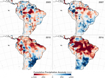
Conditions created by the strong El Niño event that warmed up Pacific waters in 2015 and early 2016 altered rainfall patterns around the world. In the Amazon basin, that meant reduced rainfall during the wet season, plunging some parts of the region into severe drought.
According to NASA, the Amazon is the driest it’s been at the start of the dry season since 2002 — and that probably means the rainforest is in for a particularly nasty wildfire season, according to Doug Morton, an Earth scientist with the U.S. agency and a co-creator of the Amazon fire forecast, which uses climate observations and active fire detections by NASA satellites to predict fire season severity.
“Severe drought conditions at the start of the dry season have set the stage for extreme fire risk in 2016 across the southern Amazon,” Morton said in a statement. The Brazilian states of Amazonas, Mato Grosso, and Pará are reportedly at the highest risk.
Per NASA’s Amazon fire forecast, the wildfire risk for July to October now exceeds the risk in 2005 and 2010 — the last time the region experienced severe drought and wildfires raged across large swaths of the rainforest. So far, the Amazon has seen more fires through June 2016 than in previous years, which NASA scientists said was another indicator of a potentially rough wildfire season.
NASA’s forecast model, developed by scientists at the University of California, Irvine (UC-Irvine) in 2011, focuses on the link between sea surface temperatures and fire activity. Warmer sea surface temperatures in the tropical Pacific Ocean, which occur during an El Niño event, as well as in the Atlantic Ocean are known to shift rainfall away from the Amazon, thereby increasing the fire risk in dry months.
Sea surface temperatures in tropical Pacific waters from October 2015 to April 2016 were at record highs relative to the 2001-2015 average, according to UC-Irvine scientists. At the same time, sea surface temperatures in the tropical Atlantic from January to April 2016 were also above average.
The Amazon fire forecast team also tracks changes in terrestrial water storage (TWS) during the dry season. NASA’sGRACE satellites registered below-average TWS across most of Amazonia in March 2016, which means there was less soil moisture recharge from wet season precipitation than in previous years.
“When trees have less moisture to draw upon at the beginning of the dry season, they become more vulnerable to fire and evaporate less water into the atmosphere,” UC-Irvine scientist Jim Randerson, who built the forecast model together with fellow UC-Irvine scientist Yang Chen, said in a statement. “This puts millions of trees under stress and lowers humidity across the region, allowing fires to grow bigger than they normally would.”
Scientists at NASA and UC-Irvine have been working with South American officials and scientists to make them aware of these data and their implications.
Liana Anderson of Brazil’s National Center for Monitoring and Early Warning of Natural Disasters said in a statement that “fire forecasts three to six months before peak fire activity are important to identify areas with higher fire probability for integrated planning.”
Source: news.mongabay.com


